
Illicit waste management is among the most fruitful activities for environmental crime organizations. In 2020 the annual revenues for hazardous waste trafficking in the EU were estimated between 1.5 and 1.8 EUR billions, whereas profits from non-hazardous waste trafficking ranged between 1.3 and 10.3 EUR billions [1]. These numbers highlight the need to innovate the investigation processes of environmental protection agencies and law enforcement authorities against improper solid waste management. The recent advances in artificial intelligence along with the increased availability of very-high-resolution remote sensing images offer new opportunities for contrasting such environmental crime. Within the PERIVALLON project we have therefore implemented and validated a novel tool leveraging advanced computer vision techniques to support large territory scanning in search of clues of illicit waste disposal activities in aerial images.
Image classification for waste detection
The waste detection module created by PERIVALLON has been obtained thanks to an elaborated training procedure employing a vast number of satellite images previously annotated by human experts, with the goal of transferring the expert knowledge to the AI component. The trained waste detector receives as input a satellite image covering the region of interest. The image is split into geo-referenced squared tiles, which are analysed with a binary image classifier that labels an image as positive if it contains clues of solid waste or negative otherwise. A numerical score denotes the model confidence for the input tile to belong to the positive class, whereas a saliency map shows where the classifier focused to deliver a positive prediction. Both outputs can be visualized in the PERIVALLON platform along with the input satellite images. Additionally, thanks to the risk assessment module, the platform integrates additional information about each site, such as its proximity to protected areas and water bodies to assign a risk level to each detected location. This targeted approach reduces the time otherwise spent on labor-intensive tasks, such as visually surveying the entire area of interest, and enables the operators to shortlist high-priority sites for further action. These shortlisted locations can then be investigated through on-site inspections or drone overflights.
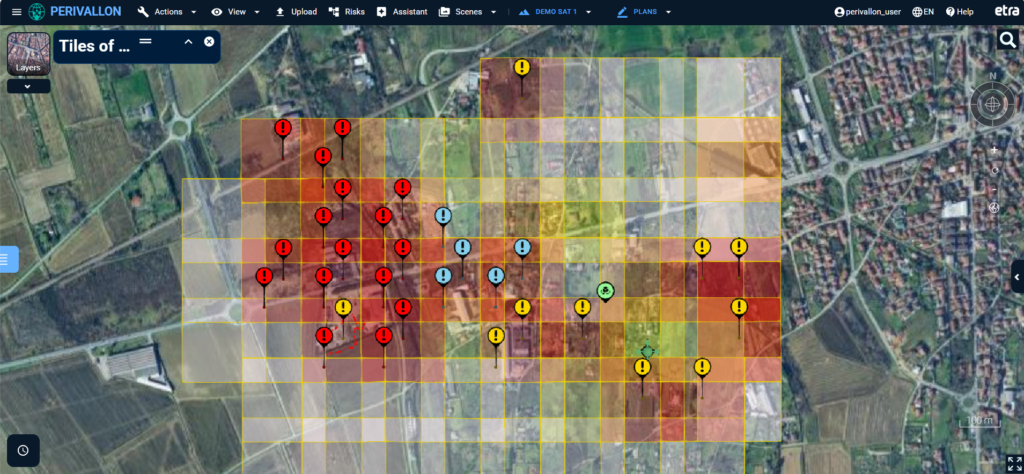
Figure 1. Visualization in the PERIVALLON platform of the results from satellite scan. Color of the squares indicates the model confidence, color of the markers describes the risk level assigned to the detected site.
Approach scalability and time saving
A thorough experimentation led to train a detector which correctly identifies waste in more than nine satellite images out of ten. The model was also tested on other locations, namely Greece, Sweden and Romania, which were of interest to the project partners and target of various project demonstrations. On these territories the model demonstrates good generalization capabilities, despite their substantial differences in morphology, land cover, land use, and waste distribution compared to the region providing the training images. Finally, an exercise involving project partners at ARPA Lombardia, who are expert photo-interpreters, demonstrates that up to 30% time saving can be attained by adopting the developed waste detector instead of performing manual photo-interpretation.
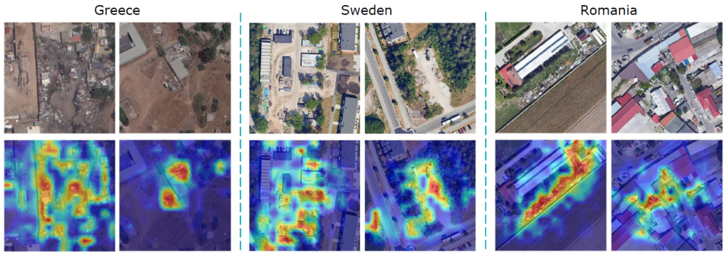
Figure 2. Examples of model predictions in Greece [© DigitalGlobe, Inc. (2024), provided by European Space Imaging], Sweden [© Google, 2025], and Romania [© Google, 2025]. The second row highlights the presence of waste (red areas) in the samples.
The largest waste data set made available to researchers and practitioners
The waste detection module was trained on the AerialWaste data set, which is openly available on Zenodo at https://doi.org/10.5281/zenodo.12607190. This contribution will help the community of researchers and practitioners to replicate the approach of PERIVALLON to waste detection in satellite images. The international uptake of the PERIVALLON results is demonstrated by the number of downloads of the data set, which at the time of writing exceeds 7,000 downloads from all over the world.
[1] Europol, Environmental crime in the age of climate change – Threat assessment 2022, 2022. https://doi.org/10.2813/54422Written by Piero Fraternali
Politecnico di Milano